
Overview
Browse more than 500 pages of
images and information related to
inland diatoms from the
Antarctic continent and
Subantarctic Islands
- View images to assist diatom identification.
- Browse taxon descriptions such as length, width, original type description, and references.
- Search samples to see what taxa are present in stream algal mats, sediment cores, and water samples (McMurdo Dry Valleys only).
- Browse waterbody information such as location, setting, map, and photos (McMurdo Dry Valleys only).
- View individual diatom counts to check relative abundances (McMurdo Dry Valleys only).
This site is part of an ongoing effort to discriminate between Antarctic species that are relatively recent invaders from those that are relicts of a warmer past.
Please visit our "companion" site: Antarctic Cyanobacteria and our related sites: Diatoms of the United States and Rocky Mountain Lake Algae.
Recent Major Updates
:
Citation
Any publications that use data obtained from this web site should, when possible, cite the original publications. Otherwise, use the following:
Spaulding, S., Esposito, R., Lubinski, D., Horn, S., Cox, M., McKnight, D., Alger, A., Hall, B., Mayernick, M., Whittaker, T., and Yang, C. Antarctic Freshwater Diatoms web site, McMurdo Dry Valleys LTER, visited at http://huey.colorado.edu/diatoms/
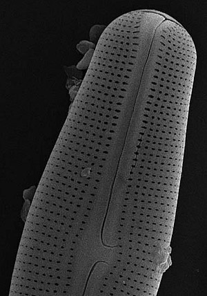
Muelleria peraustralis (West & West) Spaulding & Stoermer, a species found in a number of coastal Antarctic streams and lakes. This image shows a cell approximately 35 micrometers in length.
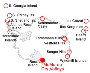
Antarctica. Location of sampling sites, including the McMurdo Dry Valleys (MCM) and other regions.
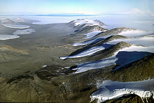
Taylor Valley. View to the east through one of the Dry Valleys. The Kukri Hills dominate the right side of the picture. McMurdo Sound and Mt. Erebus (uppermost right) are visible in the background. Near the coast and extending into the valley is Commonwealth Glacier (upper left), with Lake Fryxell bracketed between Commonwealth and Canada glaciers. Photo: Mike Prentice, UNH, VALMAP GIS web site.