
Overview
Many images and data for this web site are organized within a web-friendly, custom-designed relational database. Members of the research team can do the updates themselves, without requiring technical web knowledge. But some portions of the site are not yet automated, such as the generation of maps.
If interested in knowing more about the basic database structure and web coding, please contact the Project Leader with details about your interest (we may publish something later). Keep in mind that we cannot give you the current structure and code as it is fairly customized and not easily shared with others. In the future, we hope that our code will mature to make it easier to transfer to others. If you are keen to get access to it sooner, we might be able to assist you but only on a contract basis as our schedule allows.
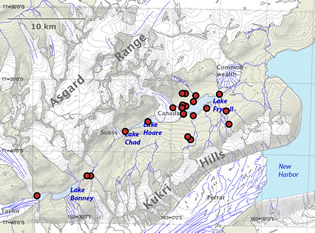
Samples. Some sampling sites in the Taylor Valley. Basemap created from the MCM LTER GIS database.
Basic info
- 4614 samples
- 59 waterbodies
- 284 taxa categories active (species & subspecies)
- 22 taxa categories inactive (species & subspecies)
- 856 diatom
counts active
- (56 taxa categories active)
- 0 diatom counts inactive
- 1581 diatom images active
- 109 diatom images inactive
Major Updates
This site and its data are frequently updated. Only the major changes will be noted here, such as posting a large batch of new images, adding several new taxa, or updating the functionality of the user interface.
2010-03-18: Web site expanded to include taxa from other locations on the continent and subantarctic islands. (ver. 1.5).
2005-02-25: Web site launched (ver. 1.0).